Ancient
Indian Walls
By
Captain William N. Page
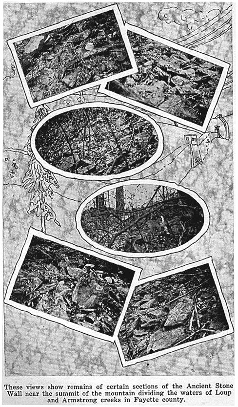
"Near
the summit of the mountain dividing the waters of Loup and Armstrong
creeks, in Fayette county, West Virginia, there is found the remains
of a very remarkable stone wall, which was well known by the first
white settlers in the Kanawha valley, and to the Ohio Indians who passed
along this route in hunting and other expeditions, toward the valley
of Virginia, where, according to their legends, the buffalo migrated
periodically from the Ohio valley, and further west.
The
late Dr. Buster, who was among the first white residents of the Kanawha
valley, resided at the foot of this mountain, on the south bank of
the river, during a long and active life. No white man had ever occupied
the ground upon which his father built his cabin, according to record;
and history of the paleface here, is absolutely complete within this
family. Paddy Huddleston, probably the first white settler within
the limits of Fayette county, lived just up and across the river, practically
in sight; and from his house Daniel Boone trapped beaver. In my
last interview, about 1877, though a very old man, his mind and body
were still active and vigorous. He remembered talking to the Indian
'medicine men' in his boyhood, as they frequently passed up the river,
and discussed this wall with the numerous relics of bones, stone implements
and pottery found all over the surrounding bottom lands. According
to his statements the Indians knew of these monuments, but claimed no
part in them. One of their legends sets forth the fact that the
Kanawha valley had been occupied by a fierce race of white warriors,
who successfully resisted the approach
of the 'red man' from the west for a long time, but had finally succumbed,
and passed away in death. The Indians claimed never to have occupied
the valley, except for hunting expeditions; that they found these relics
old when they first entered; and that their origin was beyond their records.
Though
such legends are not always reliable, a careful study of the conditions,
habits of the people, and the bones found at the foot of the mountain,
inevitably leads to more than the suspicion of a prehistoric race,
differing from the North American Indian in physiognomy, character
and habits.
Loup
and Armstrong creeks empty into the Kanawha from the south, and are
nearly parallel - three miles apart - for a distance of about ten miles. Like
the river, both creeks have cut deep gorges through the nearly horizontal
carboniferous strata, and the smaller tributaries, heading against
the 'divide,' have also cut out to the creek level at the points of
junction. The result of this denudation is a mountain, rising
1,500 feet above water level, with ribs, holding their altitude well
toward the creek, while the main backbone, or watershed, has alternate
knolls and low gaps, with a difference of about 300 feet elevation
between the high and low points. As the hard sandstone or of
the 'conglomerate series' are under water level here, the softer, overlaying
strata of the 'lower barren measures' have been weathered so that the
slopes are comparatively smooth.
The
wall in question has been constructed along the approximate contour
of the mountain, about 300 feet below the high summits and just under
the low gaps, conforming as nearly as possible to such contour, it
winds around each rib, or spur, until a low place is found through
which to pass, when it finally crosses the main ridge and returning
in the same manner on the other slope, makes a complete enclosure facing
the river, of about three miles in length and varying in width from
a hundred yards to a mile, or more.
The
total length of this wall has never been measured, but can hardly be
less than eight or ten miles. A single cross wall at a narrow
point divides the enclosure into two nearly equal arms, in one of which
there is an unfailing water supply of more than a half cubic inch of
flow, from a coal measure which has been cut by a low gap at this point. When
I first saw this spring in 1877, the existence of this coal measure
was unknown, and the old hunters of
the neighborhood were under the impression that the water came from
a well, sunk upon the watershed of this gap and filled up by leaves
and time. It was a circular pool about six feet in diameter,
and three or four feet below the surface. Dr. Buster stated that
it was at least ten feet deep when he first saw it, and held to the
opinion of a well; but I am satisfied now that it is only the drainage
from the coal seam mentioned, upon a floor of impervious clay. It
is located on the dip side of the coal escarpment, which by actual
survey covers an area of thirty-seven acres, with a maximum covering
of about 200 feet. The hole has probably been scooped out by
bear and other wild animals, as marks upon the neighboring trees from
bear claws is evidence that this has been, as is yet to some extent,
a favorite wallow, in which they roll like swine, and in their gambols
they claw the bark of trees so as to leave the marks as long as the
tree may stand.
Near
this spring, however, and within the partition farthest from the river,
there has been recently found two large circular heaps of stone, indicative
of some kind of tower structure; and it is more than probable that
their location had reference to the water supply, which is not found
elsewhere within the structure. These circles were about twenty
feet in diameter, and their present appearance indicates an original
height of about twenty feet.
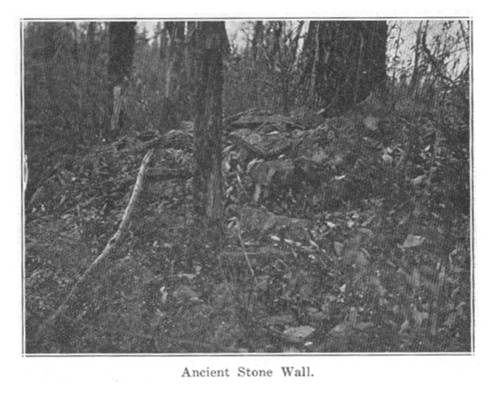
The
wall itself has been constructed of loose stone, without any kind of
cement, and of such dimensions as could be readily handled, without any
attempt at quarrying or facing. Along the steepest slopes it has
fallen and can be traced only by the bench of debris, but in some places
where it crosses the ridges, and has level foundations, some idea of
the original dimensions may be had. It is safe to estimate a height
of six feet, upon a foundation width of from six to eight feet. Nearly
all the loose stone within the enclosure seems to have been carried out
for use in the structure; but in many instances blocks of 'black flint
ledge' may be observed in the wall, and since the outcrop of this ledge
is lower down the slope, it is certain that such stone had been carried
up hill. This fact alone is evidence of human labor; but no one
can follow the traces far without ample proof of some crude architect. Though
at an altitude of two thousand feet above tide, huge trees abound, many
exceeding five feet in diameter, with hundreds of years growth. At
points may be seen oaks four feet through, evidently sprouted since the
foundation of this wall was laid, as the stones have been lifted and
misplaced by their growth. Wherever a cliff has been encountered,
it has been utilized as far as possible, and as a rule the wall has been
joined to such cliff at the foot, rather than at the top. This
would indicate an object to guard against entrance from without rather
than to prevent escape from within, as in some instances the cliffs have
sufficient slope to enable ordinary animals to descend, but are too steep
to climb. The wall has been built with so much batter and so roughly
that it could never have been intended for any kind of fortification,
nor to confine, nor to keep out, any but domestic animals.
The
flat lands along the south bank of the river, between the mouths of
these creeks, and immediately in front of that portion of the wall
facing the Kanawha, varies in width from five hundred to two thousand
feet wide, while the bottoms on the opposite side are very much more
extensive and better suited for agricultural purposes; yet the greater
portion of the bones and relics are found on the south or wall side. About
two hundred acres of this bottom land, near the mouth of Armstrong,
is literally filled with bones and implements of some human race, whose
history has been buried with their dead.
Four
years ago, in the construction of a railway, it has become necessary
to cut through a part of this ground, near where the old Buster cabin
had stood. This cut was about two hundred feet long, thirty feet
wide, and with a maximum depth of ten feet. Within a distance
of one hundred feet there were uncovered about thirty skeletons, all
buried in a like position, at an average of four feet. There
was no evidence of mound, or monument of any kind except a few loose
stones piled upon each set of bones, below the surface, and there was
no indication to point to this particular spot, which was near the
river's bank. Without exception the bodies had faced the east,
or rising sun, in a horizontal position from the hips down, and reclining
at an angle of about thirty degrees from the waist up. The bones
were in a fair state of preservation, but many crumbled with the hand. The
soil being a sandy loam, had filled every crevice and marrow duct,
so that even the skulls were crushed with the weight of handling and
it was with much difficulty that anything was preserved.
I
measured several skeletons in position and found them to average about
five feet, ten inches. With one exception, the cranium was well
proportioned, with broad and prominent forehead, and facial bones more
nearly resembled the white, than the red race. This exception
was in all probability, a deformity, else it was a very much lower
order of animal intellectually, though not physically. The teeth
indicated an age of about twenty-five, and imbedded in the front of
the lower jaw bone was a fully developed tooth which had never penetrated
the bone. The skull was canoe shaped, sharp front and back, long
and very narrow. The occipital bone was out of all proportion,
curved under, and terminating in a sharp point. The parietal
bones occupied nearly the entire skull area, as the coronal and lambdoidal
sutures were so far forward and back of the usual position that both
the frontal and occipital bones were curiosities. The frontal
bone was also pointed, and there was no break in the canoe curve from
the eye to the nape of the neck. Other bones denoted full and
complete development; but he must have been a fearful sight in life.
Along
with these bones were found those of many food animals, such as bear,
deer, elk, &c., birds and fish scales. About three feet below
the surface, a regular stratum of phosphate, about eight inches thick,
extended over the greater area of the cut. Upon close examination,
enough fish boned and scales remained to indicate its origin. In
places bits of charcoal, slag from melted sand, and pieces of charred
bone showed that they feasted on cooked meats. The implements found
were all stone, pottery and bone. The stone instruments consisted
of greenstone celts, precisely the same as those of the Continental stone
age, scrapers for dressing hides, flint spear and arrow heads in great
abundance in various sizes and shapes, and a lot of quoit-shaped stones,
which had been marked and evidently used in some system of weights, as
many are exact multiplies of others. The arrow heads were nearly
all of the war variety, made to be left in the wound, but not notched
fro a thong fastening, as was customary among Indians with their points
for game. Some of these points were the sharpest and slenderest
specimens of flint workmanship I have ever seen; they were no more than
two inches long
and less than half an inch at the shaft end, or widest part, tapered
to such a fine point that they could be used comfortably as pin to prick
splinters out of the hand. One, in particular, had three sharp,
equal points, which at the shaft end (for which it was notched), made
a cross, or four pointed star. The spear heads were unusually
sharp and made for business, as was the case with the edges of the celts. The
pottery, like that found in the valley, was made from the river mussel-shells,
coarsely pounded and mixed with loam. A great variety was found,
some of the pieces were large enough and nearly perfect, showing the
effects of use, and heat over a fire. The bone implements consisted
mainly of long needles, awls, etc., for the manufacture of skins. The
eye of the needle was notched to receive the thong, on the same principle
as ours today. Those which had been polished were as sharp and
sound as when made from the small rib of a deer; but the unpolished portions
of the awl had crumbled off. In the same line of bone there was
also found 'wampum' made from very small segments of the spine of some
fish or reptile; and the value of each piece seemed to depend upon the
amount of labor which had been bestowed upon it. There were no
holes through these beads, nor arrangements for stringing them together,
consequently they could not have been intended for any kind of ornament. They
varied in size from a No. 8 to a No. 2 shot, but each had been carefully
polished. Imbedded in the sand, in the mouth of one of the skulls
were found two pieces of thinly beaten copper, nearly three inches long,
and rolled as if around an arrow shaft; they had probably been one, but
broken in two. This was the only metal found; and only one steatite
pipe, with the stem very accurately bored and split in halves. The
nearest steatite in position lies east of the Blue Ridge, in Virginia,
and neither this nor greenstone is found in the river silt.
The
first question is: Who built this wall, when, and for what purpose? It
may be safely assumed that it antedates any historic records or legends
in our possession. The Indians found here knew of its existence,
but nothing of its origin or purpose; and as far as we know they were
not a race to undertake manual labor. The theory among old hunters,
that it was a game pen, is refuted early in examination, since nothing
but a domestic animal could be fenced by such a structure. That
it could have been intended for any
kind of agricultural purpose seems equally as improbable for the same
reasons, and for the further reason that the location is practically
inaccessible, while the valleys below were broad and fertile. In
portions of the enclosure there is a deep, rich soil; but a large part
of it is barren, rocky crest, which would certainly have been left
out where the same labor might have been employed. There remains
the question of fortification, which seems equally as improbable, except
so far as it might have afforded immediate protection in actual fight;
but with the weapons probably in use, a tree would have answered the
purpose better. Though the towers may have a war-like sound, as
a matter of fact they were in a position where they would have been of
the least service in defending the wall against an outside attack, though
they might have served to defend the water supply.
It
seems to me that we must look for some other object and conditions,
entirely foreign to any Indian custom; and that not only the bones
at the foot of the mountain, but the archaeological history of the
entire Kanawha valley furnishes a clue. That the Kanawha valley has been densely
populated by some prehistoric race, differing from the Indian in intelligence,
manners and customs, there can be little doubt. The soil everywhere
bears indisputable evidence of their numbers and handiwork, beside which
the hundred years of white occupancy and monuments would sink into insignificance
with a like test of time. From Kanawha Falls to Charleston, a distance
of forty miles, scarcely a post hole can be dug without disclosing some
evidence of this people. It has been asserted that the Aztecs,
or some Arian race from Mexico, had followed up the Mississippi and Ohio
to the Kanawha, and the numerous mounds found in this valley has been
cited as one evidence. Such a theory is plausible as the route
is a natural highway, followed later by the Spaniards and French without
much loss of time. It is also natural to presume that a southern
race would have settled in greater numbers along the Kanawha, than in
the upper Ohio valleys. But the question is, whether the bones
found at the mouth of Armstrong creek, without sign or monument, belong
to such a race, or to the North American Indian? The physiological
features are clearly against the latter assumption; and that they were Sun
Worshippers is demonstrated by the sameness in
position of all bodies found. The quantities of fish and bones
of wild animals, prove that they were an active race of meat eaters,
and that they cooked their food in vessels of clay; and that they were
bold is certain from the large portion of bear tusks, some of which were
enormous, and must have been ugly customers to tackle with stone weapons. If
we connect these bones with the stone wall in question, it seems to me
that it can be more readily accounted for in some Essenic religious
rite. The elevation of the mountain is such that the sun can
be seen much longer than from the valley, and the position of the towers
were favorable to such observation; and being near the center, they were
doubtless sanctum sanctorum of the enclosures, and the abode
of some high priest. It is more than probable that some kind of
serfdom or slavery existed, whose surplus labor was directed to such
monuments, probably not so much for record, as for occupation or punishment,
as the wampum shows that they placed some value on labor.
A
comparison of ages between the wall and bones would certainly not place
the latter ahead of the former, though the reverse might be the result;
but it must be borne in mind that under certain conditions the decomposition
of bone is no index to age or time, as it is pretty well authenticated
that a period of two thousand years has failed to obliterate the human
skeleton, probably as much subject to oxidation as there have been. I
am perfectly certain that the Armstrong bones are very ancient, but
I am not competent to approximate any definite time.
I
have heard of a similar wall on one of the Paint creek mountains, ten
miles down the river, but have never seen it. As none of our
race ever occupied these mountain tops and they have been rarely visited
except by huntsmen, other evidence might easily have been overlooked;
and since we have no records more ancient in connection with the human
race, it is hoped that the subject will receive more attention in the
future than in the past."
The
following lines were written by Captain William N. Page, and express
his conviction as to the antiquity of the relics mentioned in the foregoing
article:
"Entomb'd
for ages, facts and fancies, here have risen
From prehistoric records. Breaking nature's
prison -
By steps as slow as forest growth, canyon deep,
Cut through everlasting rock; with slopes too steep
To climb with naked feet. Nor can the truth
be caught
When fact is wing'd by fancy in the flight of thought.
Kanawha's floods have buried race and name,
By countless thousands, still unknown to fame.
But written records in the sands, along its winding
shore,
Is record older than the tombs of Egypt's lore." |
The
Smithsonian Institute had an investigation by Col. P. W. Norris of
the wall and of the ancient burial ground so graphically described
by Captain Page. Volume 12, Bureau of American Ethnology Report,
pages 412 to 434, contains a paper by Dr. Cyrus Thomas, which embodies
the report of Col. P. W. Norris, who died in 1885, while engaged in
explorations in the Kanawha valley. The death of Col. Norris
ended the investigation, and comparatively few of the younger generation
in the county know of the existence of the wall.
Some
years ago, a company mine the coal from under the mountain on which
this ancient wall is found. The coal seam was nearly on a level
with a part of this stone wall. One of the miners related that
when they had reached a point nearly under the center of this knoll,
they found the coal gone from under same over an area of about one
fourth of an acre, and that they failed to find any entrance to this
excavated place. It was also stated that within said excavated
place they found several small cone-shaped mounds about two feet high
which were formed of sand, which evidently had, in centuries past,
dripped from the sandstone top and finally formed these cone shaped
piles of sand, which in the lapse of time had become petrified.
The
mysteries surrounding these antiquated walls certainly provide a very
wide and interesting field for investigation.
A
recent visit by the writers of this history finds the wall but little,
if any, changed since the visit of Captain Page about fifty years ago. Two
things, however, they did discover - one, a great stone in the center
of the enclosure which was probably the throne of the chieftain of
the race or the sacrificial alter of the strange people whose beginnings
and end are lost in the mists of antiquity. The other disclosure
was that the tower on the outside of the wall apparently covers the
entrance to a cave, and the supposition is that the tower on the inside
serves a like purpose. Were these people, then, cave dwellers? To
what depth does the ancient passage way beneath the stones lead? What
would one find therein? These questions we leave for the more
intrepid to answer.
To
show that the entire Great Kanawha river valley, heading in Fayette
county, was the scene of early operations of ancient and distinct races,
we give a few notes concerning finds of the life and activities of
prehistoric people:
Ten miles below the mouth of
Armstrong creek, on the Kanawha river, is another wall similar to the
one in Fayette county described by Captain Wm. N. Page. It is on
a high mountain, facing the river, just above the mouth of Paint creek. The
characteristics of the two works are so nearly alike that the foregoing
description of the one at Loup creek renders unnecessary any description
of the one at Paint
creek, except to say that it is erected on a smaller scale.
At
the base of the Paint creek mountain, too, is an extensive burying
ground, similar to the one described. It is just where the village
of Pratt (formerly Clifton), now stands; and so numerous are the remains
that excavations for any purpose are almost sure to unearth skeletons,
as well as stone, bone, earthenware, copper implements, and relics.
Within
the village of Brownstown, ten miles above Charleston and just below
the mouth of Lens creek, is another such burying ground. Some
time ago two skeletons were found together here, one a huge frame about
seven feet in length and the other that of a deformed dwarf about four
feet in length.
Graves
at any of these places are not marked with mounds or any surface indications. The
probability naturally suggests itself that those buried there, and
who built these stone enclosures were a different race from the
Mound Builders.
Some
young men, while hunting on the mountain near Cannelton discovered
what seemed to be the walled up entrance to a cave in the face of a
cliff. Impelled by curiosity, they pried out the stones and effected
an entrance to a cavity, where they found the remains of human animal
bones, flint implements, a piece of coarse woven fabric, and some dried
berries. The berries were in flat layers between a course of
small twigs or stems below, and another course above. This is
the only instance, so far as we know, of a cave burial in the valley.
There
have been no recent examination and explorations of these ancient works
here in the Kanawha valley, except as aforementioned, and the hundreds
of ancient earth and stone works offer a rich field of study of the
ethnologist and archaeologist.
The
History Of Fayette County, West Virginia. This
book was written by J. T. Peters and H. B. Carden. It
was published in 1926 by the Fayette County Historical Society,
Inc., Fayetteville, West Virginia, and printed by Jarrett Printing
Company, Charleston, West Virginia.


CIVIL
WAR ~ PRINTS & GRAPHICS ~ BOOK
PUBLISHING ~ STORE