Civil War Books, Maps, and Research Prints and Graphics Book Bpublishing Store
 

Civil War Maps


Antietam Set
$20.00

Antietam The Series
All three major phases of this telling battle

Antietam remains one of the bloodiest battles in US history.  More than 22 thousand Americans fell that day.  The three main phases of the battle comprise the Series.  Hand drawn - full color maps with a profile of the key portion of the battlefield.  Through these profiles one can learn and understand what the ground commander had to face - why, for example, could a smaller force of Confederates hold off a much larger Union force at the Lower Bridge. Printed on textured, archival heavy-weight paper.  When framed, are suitable for hanging or display anywhere.


The Cornfield
Measures "17x22"
$10.00

Antietam - The Cornfield
September 17, 1862
1st Phase of the Battle

22"x17"

The Union objective was a plateau east of the Dunker Church.  When the first Union forces, under Gen. Duryea, cleared the North Woods, they came under a scything fire from Confederate artillery posted near the Dunker Church and from their right flank by 14 guns planted on Nicodemus Hill by J.E.B. Stuart.  more…


  Bloody Lane
Measures "17x22"
$10.00

Antietam - Sunken Road or Bloody Lane
September 17, 1862
2nd Phase of the Battle

Union forces under General French and General Richardson approached the Confederate center through the fields and pastures of the Mumma and Roulette farms. In a sunken farm lane, south of Mumma and Roulette, from right to left, the 26th, 12th, 3rd, 5th, and 6th Alabama under General Rodes and the 2nd, 14th, 4th, and 30th North Carolina under General Anderson awaited the Union onslaught.   more…


Lower Bridge
Measures 17"x23"
$10.00

Lower Bridge or Burnside's Bridge
September 17, 1862
3rd Phase of the Battle

Union forces under General Burnside, approach from the north. Two companies of the 11th Ohio made a half-hearted probe on the bridge and were easily repelled. The 11th Connecticut assaulted and managed to gain the east bank of the creek, south of the bridge, before being forced back with heavy losses.  more…


Mosby Map
Measures 11"x20"
$10.00

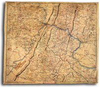
Mosby Map
Mosby's Area OF Operations

Beautiful reprint of orignal 1864 map of the area dominated by John S. Mosby during the Civil War. Measures.

 
For dealer discounts pls contact us at Gauley River Book Company